This awesome write up was sent in by Bret Cox, enjoy:
My old College roommate Dean and I both love the outdoors, and really enjoy visiting beautiful and unique Texas landscapes. After a visit to Jacobs Well in June 2012, we decided the Narrows would be our next trip, after Dean found some pictures of the place on a Facebook page. Dean, having majored in Water Management at Texas A&M, had a fairly good knowledge of Texas navigability laws, but I wanted to research myself as well. The Texas River Bum website proved invaluable in this effort, both in terms of understanding our rights, and physically what to expect on this stretch of the Blanco River.
My brother’s imminent wedding would provide the perfect opportunity, as I could use the trip as a bachelor party, killing two birds with one stone! June 8th would be the day, one week before the wedding.
Dean and I scouted out the area Saturday June 2nd, to decide how we were going to get to the narrows. The water at the 2nd Chimney Valley Crossing was flowing well and looked deep. There was water as far as we could see from the bridge. Looking at the data, it appears the flow at Wimberley was between 60-70cfs at that point. Leaving the Chimney Valley crossing, we were optimistic that we would be able to kayak a good chunk of the way at least, and hopefully the whole thing.
We headed next to the Valley View crossing, hoping to see flowing water there as well. We arrived disappointed, seeing lots of rocks and little water. We hiked upstream to see if things looked better, as we would be willing to carry the kayaks a little ways if we could paddle the vast majority. We went up a half mile or so, and found mostly dry riverbed with a few small stagnant pools. From the point at which we turned back, we could see a fairly large pool upriver, but with time constraints, we were unable to hike any further. We didn’t want to risk the unknown, so, at that point we decided the following weekend we would kayak as far as we could, ditch the boats, and hike the rest of the way to the Narrows if the water ran out.
I knew the trip would be an intense one, not for the faint of heart. My thirst for adventure craves this kind of stuff, and I was excited for it. But, I didn’t want anybody to get in over their head, so I let everyone involved know about the potential difficulties and gave them the opportunity to back out. One did, but for the others I immediately instituted a no whining policy 🙂
I was happy to see the water still flowing well when we arrived the morning of June 8th. Paddling was calm and peaceful for the first 1/3 of a mile, until we hit a check dam. The water was flowing around it to the left, and we managed to paddle, push, and scrape our way along the fast flowing shallow water to the next pool without getting out of the boats. From there until mile 1.4, we alternated paddling along the pools and dragging across the riffles.
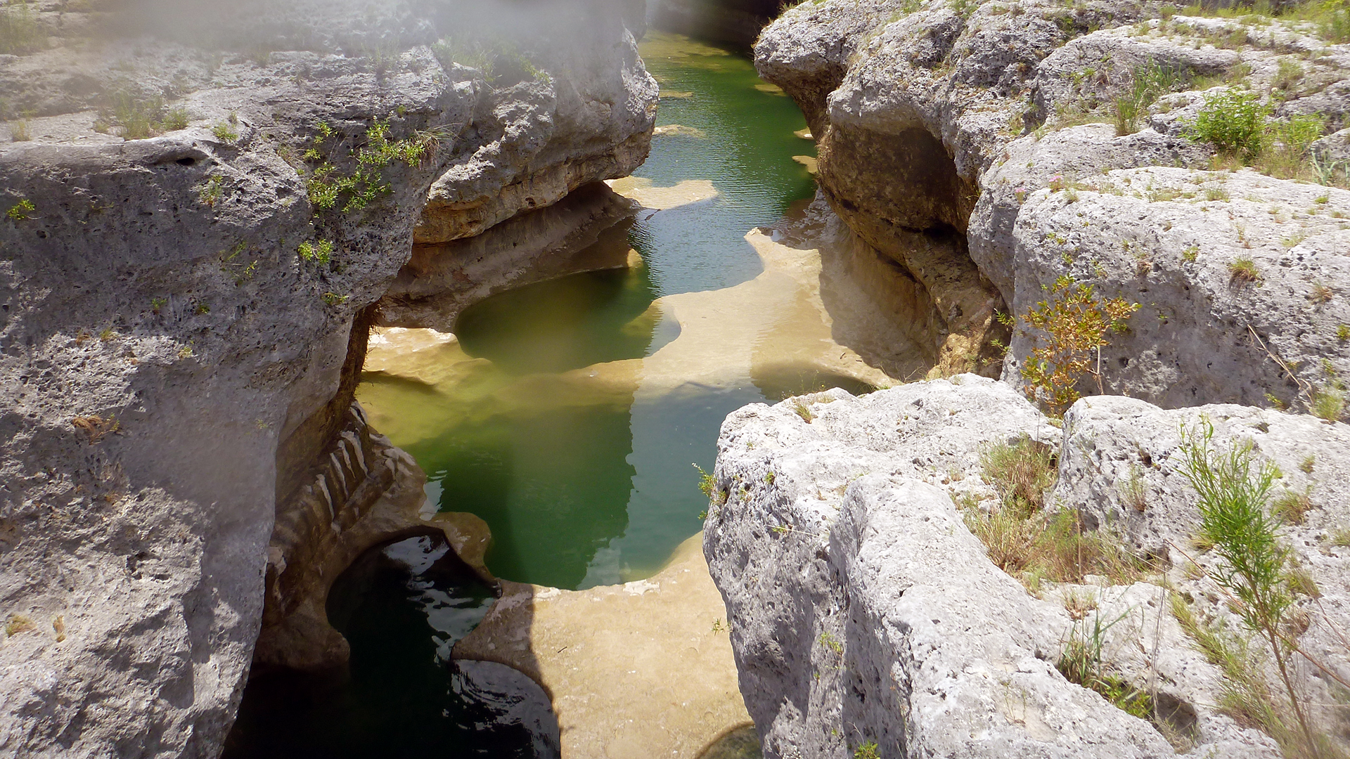
At mile 1.4, the river makes a turn east, and the water is pretty deep here. This is the same place where the Dry Blanco write-up had a picture with the caption “a rare little pool”. We plunged our paddles down to check depth here, and were unable to hit the bottom. As we crossed this section, I wondered if areas like this could ever completely dry up. It wasn’t until after the trip as I was looking back through the photos in that write-up trying to recognize some of the areas that I saw the pool there, which pretty much answered my question. If it hadn’t dried up by September 2011, that pool probably dries up very rarely, if ever.
We continued to paddle/drag our way along. The water didn’t dry up, just sections of shallow riffles that weren’t deep enough to float our kayaks. At mile 1.7, the water was barely flowing over the private crossing.

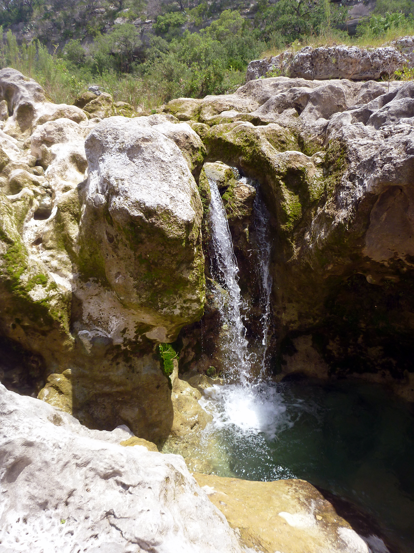
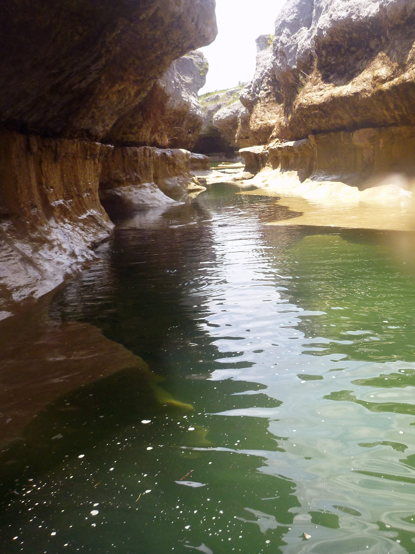
At mile 2, we found a cool little pool with a small overhanging cliff shaded by large live oaks. The cliff had maiden hair fern growing on it, supported by the water seeping from the rock I assume. On the return trip, we spent about 30 minutes here relaxing in the noticeably cool water, what I assume was ground water. The water was deep here as well, about 5 and a half feet. This section can be seen at 2:31 in the Dry Blanco video.
The alternating paddle/drag method of travel continued for the next two miles. At times, some of the group was tempted to leave the kayaks behind as they began to grow weary of dragging across the riffles. But, I reasoned as long as the water was still flowing, we’d be better off with the kayaks. Good thing we didn’t ditch them prematurely, because several long pools stretching from bank to bank still lay ahead. These would have been ridiculously tedious to trudge through on foot. We kept the boats, and paddled onward.

Mile 4.3 lay just past a long riffle stretch. Looking up ahead, we saw nothing but dry bed. I followed the water to its last point of observable flow to a small depression full of permeable gravel only and inch deep. The water flowed into this depression, but didn’t flow out of it, or even fill it up. This is where I believe the water goes underground. Here, we abandoned the boats and decided to hoof it to the Narrows. This can be seen somewhere in the vicinity of 4:30-4:40 in the Dry Blanco video, hard to tell exactly. It was also around this area that we noticed fifty or more large tadpoles flopping around in what remained of a little pool. On the return trip, the water was gone, the tadpoles had all died, and flies were buzzing about.
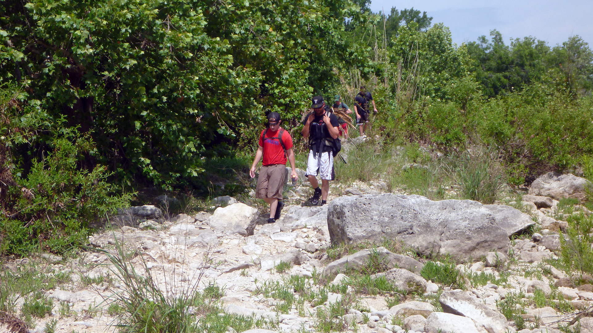
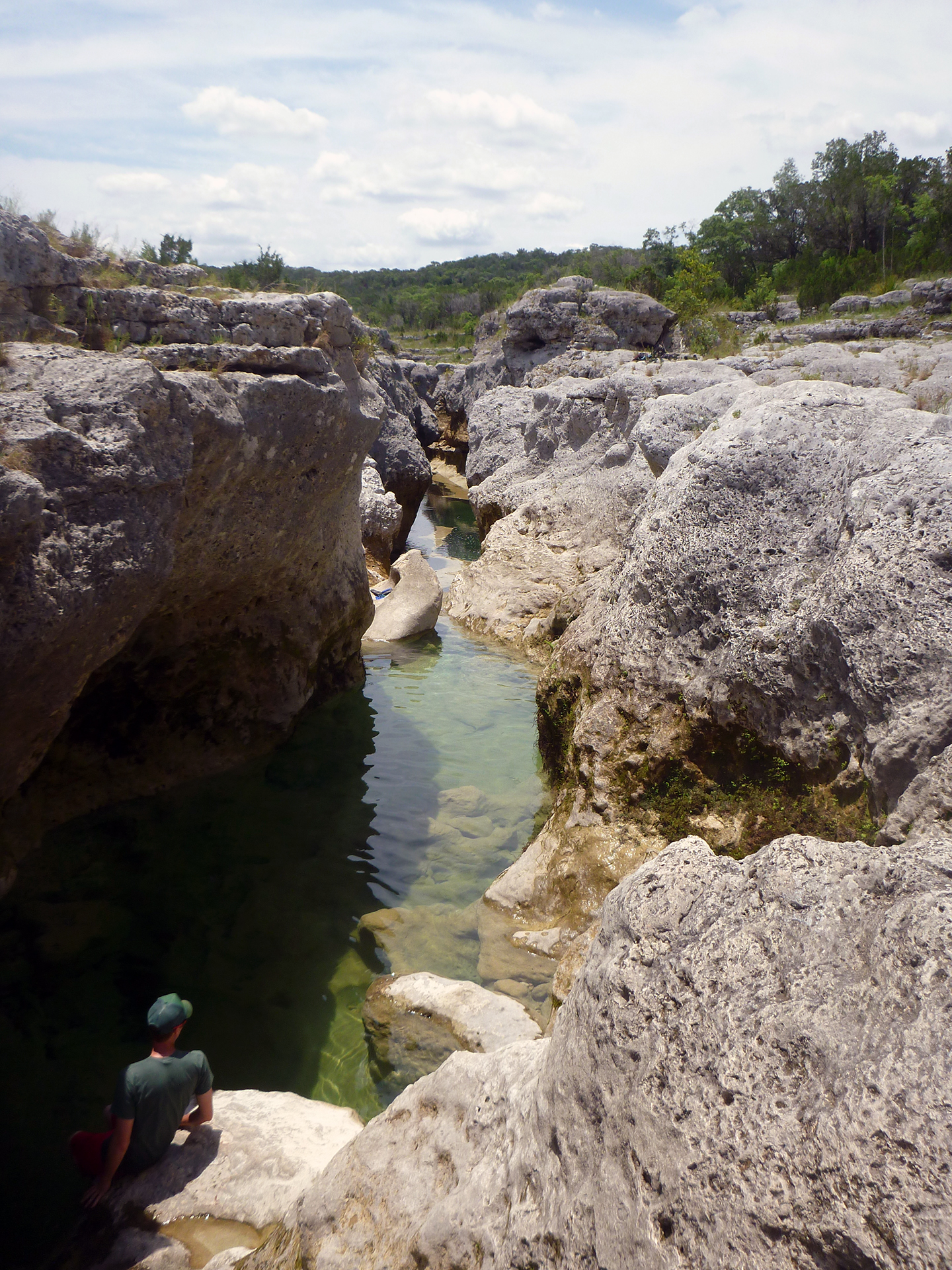
This proved to be a good call, as although there were some long pools we had to wade through and around, it would have been impractical to port the kayaks to these pools, there was simply too much difficult and dry terrain separating them. It was mostly dry along the bottom of the oxbow. From mile 6 to the narrows, it was wetter, but mostly knee deep or less, save one spot just shy of the narrows.
As we were approaching our goal, we began to hear children, and when we arrived, we were disappointed to see a group of about 20, ranging from a baby less than a year old to a man who had to be in his 70’s. I pondered how they were able to make the trip, when we in our early and mid-20’s had a pretty rough time of it 🙂
We got to talking, and it was a church group who had achieved private access. They mentioned something about Wellspring, which I looked up on Google, and is a church camp that appears to have property bordering the narrows from the map on the website. The guy we spoke with said they have cabins or houses for rent.
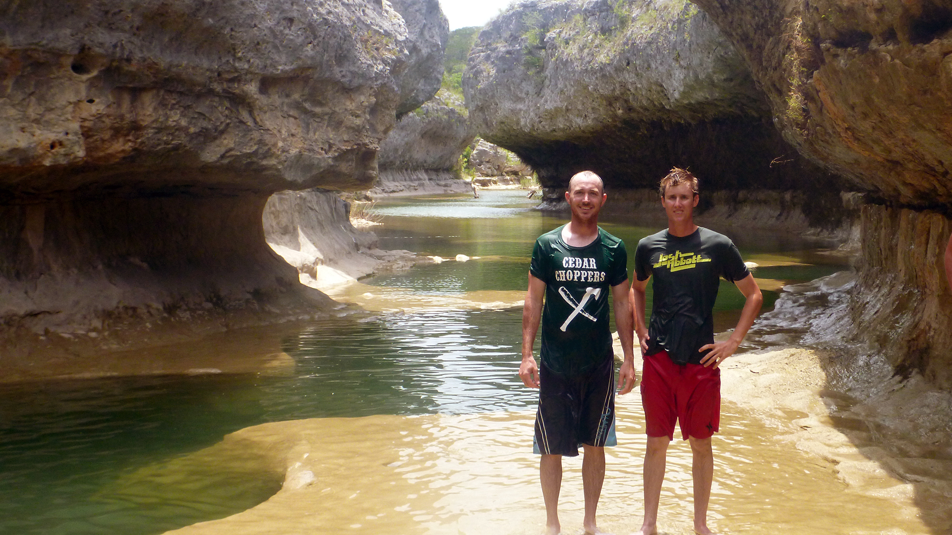
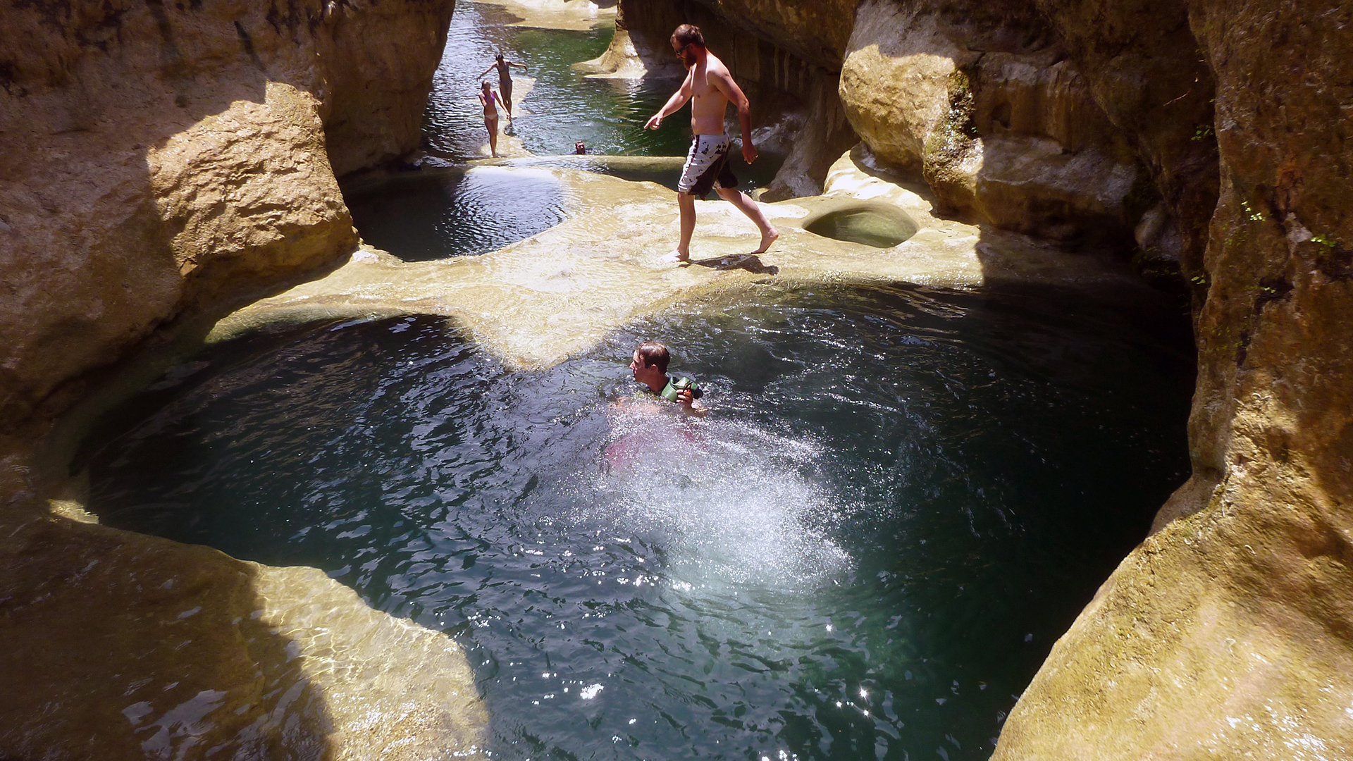
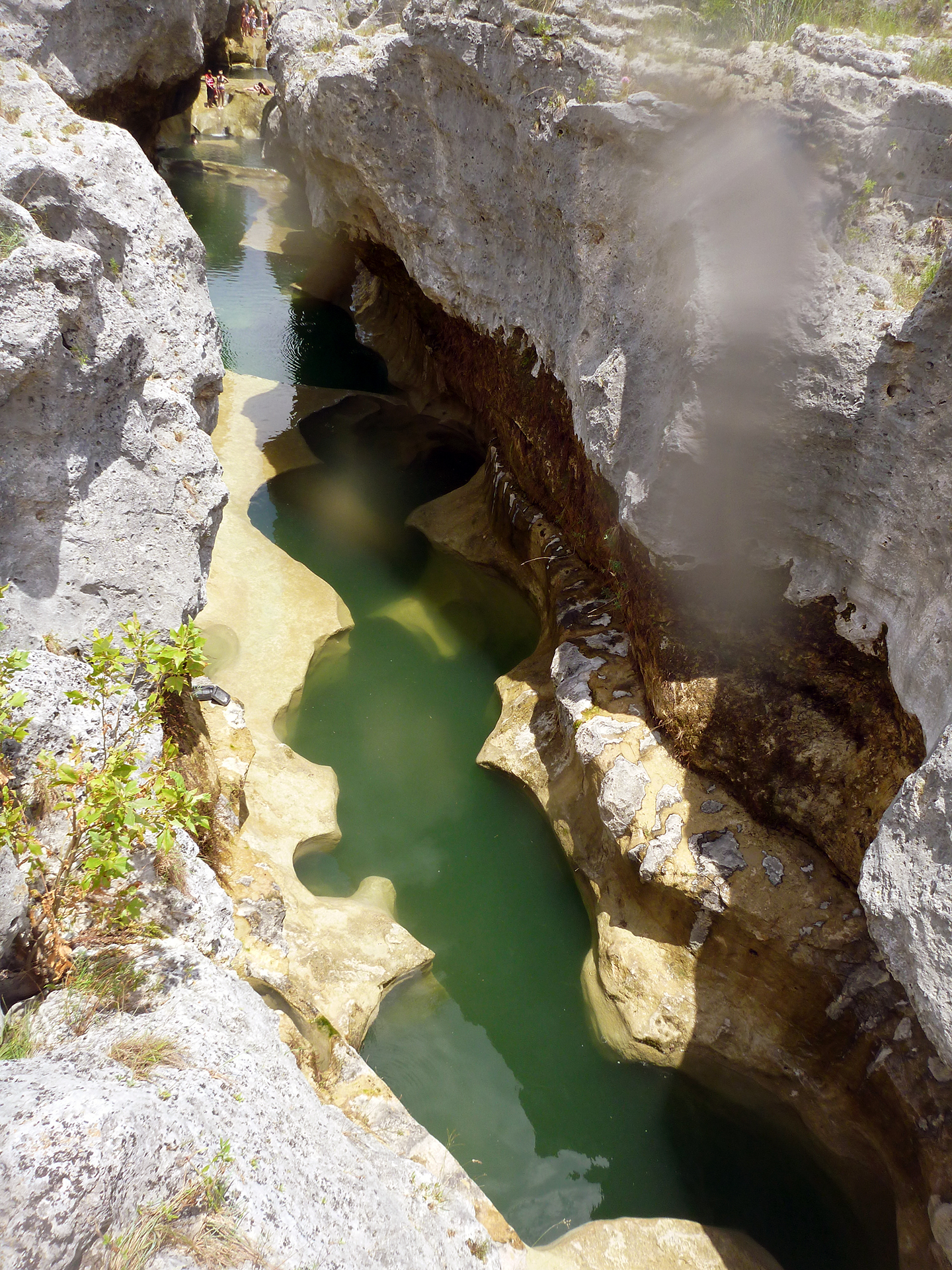
Although we didn’t have it to ourselves, the narrows was still beautiful. The water was the perfect temperature. It wasn’t muddy, but it wasn’t quite as clear as in the Dry Blanco writeup, there was a noticeable green color to all the deep pools. We ate our lunch, swam, and took a few pictures and videos, but only stayed an hour or so. I wanted to stay longer, but the travel time really didn’t allow for an extended stay. Seeing how it took us five hours to get there, we wanted to leave adequate time to make the return trip.
 Story and Photos by Bret Cox
Remember if you are thinking of traveling the Blanco River to the Narrows, the Blanco River Pocket Guide is available: http://pocketguides.www.texasriverbum.com/
Great write up! I tried a coupe months back to do my 2nd hike down to the Narrows, but unfortunately I didn’t realize it wold be full of water this time. My impression after the hike in 2011 was that it was going to take a miracle to fill up the dry Blanco- Happily proved wrong, thanks for sharing your story.
Do you know if it is still open to public?
please see the link below:
http://www.texaslandconservancy.org/narrows-othermenu-168.html
thank you!
Jessica, The land along the Narrows was always privately owned, in 2001 a conservation easement was granted TLC which protects the river easement from ever becoming developed. The ownership of the land did not change.
As far as I can tell, there is only 3 ways to visit the Narrows:
1. Befriend someone who knows one of the landowners.
2. Contact the Wellspring Retreat Center and see if they will rent you a cabin and allow access.
3. Hike and/or paddle your way down from the closest public access point as described in this write up.
You can get more information in the comments section of this writeup: http://www.texasriverbum.com/the-dry-blanco
Never has been. Water access only. PRIVATE property.
HELLO! my friend and I are looking at taking that long hike to visit the narrows very soon and appreciate your website, I have been trying to locate that retreat center you mentioned but i cannot find a website for them, could you direct me in any direction to help us visit this beautiful place? thank you so much!
Alyssa, this is the best I could find: http://www.ccca.org/public/camps/campdetail.asp?i=110878&reload=name&campID=110878 – let us know how it works out for you!
Hello All,
Found several websites on the Well Spring Retreat Center (quickest way to get to the Narrows) which is also called Wessendorff Ranch. It is an Episcopal Retreat Center. 1st website below is a pdf info on the place, but it has phone #’s and email addresses listed to contact. Never know might have to join a retreat and stay there to be able to get to the Narrows.
http://www.uumc.org/wp-content/uploads/2014/03/Retreat-Brochure-2014.pdf
http://www.hw-foundation.com/index.php?id=49 The foundation that supports the Retreat Center
If you google: Well Springs Center, Blanco, Tx. there is more
When is the best time to visit the narrows?
Jaci, I would think that early May would be ideal.
For anybody looking to visit The Narrows, please don’t do it unless you have permission from the land owners. Texas navigation laws make it to where nobody can technically own The Narrows, but in Blanco if you do not enter the riverbed legally then you will be considering trespassing, and it is illegal to access the river from road crossings. On top of that, the beauty of this place, as well as the species that habitat it, become more endagered anytime somebody makes there way out to it. You would not believe how many endangered species inhabit this small area. If you have seen this place, then good for you, but please keep it to yourself. If you do manage to find this place and run into the owners, you will regret making the trek.
Nick; you are correct about it being trespassing to cross private property to get to the riverbeds however, all public road crossing are just that – public. These public road crossings also have a public easement so it is very much within a persons legal right to enter a riverbed from these crossings. That is, if the riverbed falls under the statue of legal navigation. Details on this can be found here: http://www.texasriverbum.com/legal-access-texas-rivers
I also do not believe that more than a few people would attempt to make the long paddle/hike down the river to the Narrows so the is no danger from too much human exposure from these people. Besides, the local landowners typically have groups of people out there several times a week in the summer using it as a swimming hole.
Dave
you must be one of the landowners! there are some of us who do not litter or trespass or any of the other numerous obscenities that people going there intolerable. The disgrace is trying to keep people from seeing the beauty that god created for all of us!!!! When you get to heaven, ask god about hoarding something all to yourself and use intimidation and lies to further that end . You wont be there long!
Sorry for the typos.
If this is that difficult to be able to see, then do you know of something else in Texas, we could visit. Something beautiful like the narrows. We were planning to go this summer until I read your information. Thanks in advance!…………Mary
Mary, part of the beauty of the Narrows is its remoteness and usually getting to enjoy it without anyone else around. That said, there are a lot of really beautiful river features in the Texas Hill Country that have access difficulties ranging from drive up and get out to paddling 6.5 miles up a river. I guess I really need to know more about the experience you are looking for.
Dave
WOW!! Never heard of this at all…..how amazing to see. And what a great story!!! Beautiful photos too. I’d like to check out the cabins you mention. 🙂
any luck on finding info about the cabins?
WOW!!!! Thank you for the step by step and inspiration to get out there and see this wonder of texas. Thanks again
Mitch
What will the Narrows look like in early July? Will they still be swimmable?
Greg, the Narrows typically has water all year welling up from the deep caves. Because the water is always cold, its better to go there in the heat of the summer. So yeah, July would be fine.
Thanks man good idea on looking up legal info never thought of doing that
Anyone been out here lately? Is it hike-able without a kayak/canoe or would we be better off bringing the canoe along?
I’m with Ryan, curious if it’s doable without a kayak right now?
Ryan, Dustin – I have not been out there but its likely that you would need to paddle then hike.
I am going to attempt this hike in July and was wondering where you parkd your vehicles. Is there a place at the Chimeny Vallley crossing.? Thanks.
I’ve been to the Narrows before some time back through a small group with one of the landowners and I have a pretty full story on this place. It is beautiful. The owners keep it as a protected ecological sanctuary. The landowner informed me that trespassing is rare but is treated seriously since it is all private property stretching for 6 or 7 miles either direction from the Narrows on both sides, and that both illegal access issues to the river from the closest county roads which are apparently still a long way off (many miles) and some kind of “bank width,” issue really stretch any claims of public navigability for that particular part of the Blanco. They also told me that the few people who make it in occasionally, always trespass on private property on the bank of the river when they show up, and these are really dangerous cliffs and drop straight into the water. I wouldn’t want any children near them! They told me that they call the sheriff when anyone appears because no one can actually access that part of the river without trespassing somewhere to get there or trespass once they arrive. They don’t want people will damage the ecology which apparently has happened before. The owner(s) are very gracious people, though, and I would suggest that you try to find a way to contact one of them if you really want to see it. County sheriffs in Texas are none to friendly when it comes to trespassers.
Best in your journeys,
Nature Lover
Albert, thank you for your comment. Let me respond to you on a point by point basis.
1. The unique area is certainly beautiful and should be protected. I think the owners on the south side have done a wonderful thing by putting a conservancy easement on their land.
2. I agree, all trespassing on private property should be treated very seriously including the involvement of law enforcement.
3. It is difficult but possible to legally access The Narrows via the riverbed, on occasion you can even do it completely in a canoe or kayak. However Texas law is fairly explicit about public access by waterway which includes dry riverbeds so no, people coming up the river may annoy the landowner but it is lawful.
4. Again, if a person stays in the riverbed during the trek and while they are at The Narrows they have broken not laws – it would be a pretty broad assumption to claim that they must have trespassed somewhere or are planning to once they get there.
5. Agreed, the cliffs looked dangerous but unless you are scouting a river hazard or portaging around a hazard you shouldn’t be up on the cliffs anyhow without the expressed permission of the land owners. By-the-way, the reasonable scout and portage access is also part of Texas state law.
6. I’ve found that the Hays County deputies are wonderful, friendly people. They have been professional, knowledgeable and helpful in every encounter I have had with them.
Dave
Hi David,
Do you have any idea on how to get in contact with any of the owners to ask for permission to go to “the Narrows”? I would be travelling from NM.
Any contact info you would like to share would be greatly appreciated.
My email address is: al@sibolamountainfalling.com
Thank you very much.
Al.
Al, the south side is owned by a group of private landowners who have made it part of The Nature Conservancy so there is no access there. The north side is a private christian retreat so unless you have the ability to contact them through a ministry there is no access there either. Which is why the long and difficult paddle/hike is the only legal way to get there.
Dave
Where exactly did you park in order to hike there? I know exactly where this is located, I just don’t know where to park. I don’t want to park my car on private property and/or risk having it towed while I hike.
Thank You!!
Hi I’m very much interested in going to the narrows, how do I get there exactly and is it privately owned that ppl can’t enter once there???
What a beautiful spot. Narrows is a private property. It is part of a family ranch. It is not open to the public. This property is on the Blanco River. Check out the information at http://www.texaslandconservancy.org/narrows-othermenu-168.html. Sign up for guided tours at http://texaslandconservancy.us4.list-manage.com/subscribe?u=7aa28ee1c7ebc2541d218d4b1&id=bfb54114f6.
It is very sad how many people have learned about this place. This website is only taking away how peaceful it once was. This summer there has been an absurd amount of trespassers, and it is not being taken lightly. Chances are, if you make the trek now you will run into a landowner. If you don’t run into one of them you will probably run into somebody they hired to watch the place.
On another note,
If you access the riverbed from the spot this article recommends, you are considered trespassing. Low water crossings are not a legal access point for the river in Blanco County.
Let me address your comment point by point:
1. It is not “sad” that a lot of people have discovered a beautiful natural Texas river feature. A case could be made that it is incredibly sad how most people trash the river, but that is a different discussion.
2. “This” website is not creating the interest in The Narrows. 99.9% of the traffic coming to the 2 pages here about it are from Google searches. That means that people are hearing of it elsewhere and finding some information here. In fact, we only provide information for legally navigating the riverbed to the location. I agree that trespassers should be prosecuted. From what I gather in discussions with adjacent landowners and mangers that almost all of the problems they are having is from college age kids hearing about The Narrows on some online forum where they are advocating parking up on some county road and hopping the fence. Hoping to not get caught or get off with a warning.
3. Accessing by public road crossing is NOT trespassing anywhere in Texas: http://www.tpwd.state.tx.us/publications/nonpwdpubs/water_issues/rivers/navigation/riddell/publicaccess.phtml
I recently spoke the land manager for Wellspring. I went and asked for permission to go to the Narrows and his answer was no. He stated the owners of the property are very worried about having a lawsuit filed against them if someone gets hurt. He also said that there are many college kids who have came and been completely disrespectful towards the owners and management leaving garbage and swearig and giving the finger when they are approached.
He said every day for the past two weeks the sheriff has been out and arrested people.
I then spoke to Hays County Deputies who stated the same. They have issued warrants on every person they find there for Criminal Trespass and often times have just arrested them on the spot.
When asked about making the hike on the river they stated that is the only legal way to do it. The deputies made it very clear that they are out there multiple times a day every day making arrests etc.
while many here say it’s sad it’s not readily available to the public, I say heaven forbid you have to work for a reward. In this case it will be well worth the miles.
I found a photo in the Johnson City Court House this afternoon of the Blanco River Narrows in the hallway. This photo peaked my interest in knowing more about the county that I live in. Thank you for providing this website for me and others to learn about the Narrows. Now that I know what the narrows are and have see photos from your website I don’t feel that I need to travel there myself.
Thank you
So I would like to attempt the to view and photograph the Narrows. As stated I will do the legal way.
3. Hike and/or paddle your way down from the closest public access point as described in this write up.
I will be hiking what is the best place and coordinates to start?
I have tried to get there two times and nothing and been on the northern end Taylor Ranch Rd and nada! What about the south end like longhorn trail or narrows? Thanks
The Narrows – N30 03.388 W98 17.262
Source:
http://www.texasriverbum.com/the-dry-blanco
Josh we did it from the “2nd” Chimney Valley crossing where Chimney Valley Road crossing the Blanco River. The coordinates for that crossing are: N30 05.273 W98 19.501
However, I recommend reading the latest comments on the Dry Blanco article as there is a discussion about possible problems parking there.
Hello David I’m planning on making this trip today , I was wondering if you know the mileage between the 2 gps coordinates you posted.
From chimney valley to the narrows ?
Thank you sir
7.5 miles – 15 miles round trip.
David,
I hope you realize that this place could become just like the rivers if too many people gain access. Those same people who trash the rivers are also trying to come visit this place, and you’r website makes it that much easier to find. Yes, nobody directly searches for your page, but when you search for The Narrows it is the first link on Google. The route that you encourage is far from easy, and anybody willing to do that will most definitely be respectful of the place, but unfortunately there aren’t too many of those people. With information given in this article and comments, people can pin point it’s location and access it in much easier, illegal ways.
As far as the law goes, thank you for posting that link. It is very interesting as it contradicts the law set in place for Blanco. I’m going to have to look into that more.
I think the issue of illegal access by the irresponsible idiots that are trying to find way down to the Narrows is a separate issue and one I would gladly join your side. Like you said, few people are going to do the 15 mile (there and back) hike down that very rough and blazing hot riverbed and the those who do are much more likely to be good custodians of the area while they are visiting.
One idea I was thinking of suggesting to the landowners is setting up motion activated cameras along the road where these idiots are parking and hopping the fence. They can set the cameras to send them text messages when they detect movement and then could be checked up on. Also they could submit the photographs to the sheriff’s department as evidence (including the license plates) for the ones they didn’t catch. I wish there was a way to make it greater than a class C misdemeanor, nothing like a little jail time as a deterrent.
Lastly, the county doesn’t set the laws for river navigation or public road access. That is all done at the state level and is uniform across all the counties of Texas.
I’m going to respect nature, the land, the land owners, and the law.
I’m going to take the 15 mile hike there and back.
Ive been following this with interest because I love nature and am looking into buying some property with water. I’ve looked at property, considering it for purchase, along the Guadalupe and Frio (and the Colorado) and Brazos rivers, and it’s understandable when you buy property along those rivers there that they are navigable both by law and in fact that should be respected. People should be able to float and canoe along actual river ways, and to fish and have reasonable use of actual waterways for recreation or whatever. But, my concern is that some law that made sense in the past are now being stretched to include usage of some rivers and streams where the in fact portion of the “reasonableness,” of the law, is very thin indeed. Much of the Blanco in my opinion, would fall into this category. I’ve looked into these laws fairly aggressively, and it’s hardly clear that the public has a absolute and inalienable right to use, as is presented sometimes on the net. In early days, the State was interested in navigability because the waterways were needed by the settlers as means of transport – when there were few roads and there was a public interest in having commerce (pelts and hides and sorghum, etc.) move on dugouts and barges or on riverbeds as freely as possible – without facing a toll evert time that they came to a new landowner trying to move their goods. That made sense, certainly, but frankly there is not much commerce moved by dugout and canoe anymore and the pelt business is relatively unimportant. Today, the main interest of the State is applicable only to some very large or special waterways where anything of value is actually transported. That’s a minority of waterways for sure. The Blanco would not fall into this commercial category and never did. As it stands now, the State is still interested in navigability primarily because of Mineral Rights and how navigability has been interpreted on some lands and riverbeds giving the State an important interest in the mineral rights underneath the riverbeds. This, of course, provided income on oil and gas produced under those riverbeds and that money went (and still goes) to the State’s coffers. However, the Hill Country is largely if not entirely devoid of any mineral production and the State has no mineral interests of value in that part of Texas. The State’s real interest is therefore limited. And, many of the landowners in the Hill Country own their property to the center of the riverbed anyway, and this is the case with the Blanco and with many of the rivers I mention above. So, even if the river is deemed navigable, the State doesn’t own the Minerals. It’s probably only a matter of time before questionable navigability laws that have long passed any intrinsic utility for the State are challenged. And perhaps challenged successfully. I would be careful not to mess things up for all of us who are the “public,” by stretching the legality of public access laws on technicalities where landowners become agitated. Laws frequently cave on technical issues given enough time. On the Trespassing issues mentioned in these emails, a small amount of agricultural property in Texas that I own, Trespassing is definitely a Class B Misdemeanor and this DOES include the possibility of jail time, a significant fine, and is a permanent criminal record. I am sure that this is the case with most land in the Hill Country and around the Blanco river.
After 40 years in Texas, this month was the first I heard of the Narrows. My wife showed me a picture of an extraordinary place, I did a little research. Then I mentioned it to a few friends, and several had recently heard of it too. One said he saw a YouTube video, another that she saw it on Facebook.
So let’s be realistic – the Narrows has been noticed by the information horde. And many public places, the real gems like this, are really full of people these days. It makes sense that this amazing place has attracted attention.
Thank you David, for providing a space for reliable and considerate information. Making sure that everyone knows the law, and encouraging people to be respectful, these things are helpful to the dialog.
In regards to the issue of public access spaces – it is little enough that we have a few public waterways in Texas, and a smattering of parks and forest. We all together would benefit from more common spaces, not less.
I mean, the world is getting fuller, but what can you do about that really? I think we may be better off just to relax, and everyone keep it respectful.
I’d encourage people thinking about making the trip down the river bed or overland to figure out for themselves whether they want to risk getting busted for trespassing. Here’s the state rules on waterways:
http://www.tpwd.state.tx.us/publications/nonpwdpubs/water_issues/rivers/navigation/riddell/trespass.phtml
And here is what ‘navigable’ means:
http://www.tpwd.state.tx.us/publications/nonpwdpubs/water_issues/rivers/navigation/riddell/navigability.phtml#infact
I saw several police cars and the game warden at the crossing last time I went through there. There are signs right there explaining all of this that people walk right past and ignore. 40+ people have been cited for trespassing this year. Respect the land owners and the law, don’t do it.
The information in the links is valid, your assessment is a misrepresentation of that information. I suspect put here to frighten off people with untrue threats by local landowners who do not wish people taking this route.
The riverbed is legal for navigation by the public. The riverbed can be accessed legally though the public easement where the county road crosses the river. Anything else is merely scare tactics.
The Narrows is on privately owned land. It always has been, it always will be. It is not and never has been open to the public. If you are on the land without being specifically invited by the landowners, you are trespassing. If you are seen, you will be arrested. Period.
Not entirely true. The Narrows is a part of the Blanco River, a publicly navigable waterway. The fact that the riverbed is seasonably dry is not relevant to the law.
If you are speaking of the land outside of the riverbed you are correct and those who trespass should face the consequences.
I am a Native Texan and Fellow Geologist and would love to gain access to the narrows to study the geology of the feature. Who can I contact to obtain Legal Access
There are obviously some misconceptions about unqualified and open ended use of county roads. There is no parking anywhere near low water crossings in Blanco. Those are tow away zones. And a driver can’t simply park their car on a county road and leave it there for however long without some valid reason, like a real break down. Chimney Valley was originally a private road that the county took over maintenance some years back. The ranchers put the original road in, and own the property where the road is. Unlike a lot of roads that were put in originally by the government, the property lines on a road like Chimney Valley are different, and the road way is narrow, too narrow to park. Most of the ranchers or property owners don’t hesitate to call the tow truck on violators, or parked cars that are making the road un safe or that are on private property.
County roads may be maintained by the counties but the parking laws are determined by the state. Please check out the TXDOT site regarding parking regulations. Essentially it states that it is legal to park in the easement unless a condition prohibits it. Usually that condition is a local parking restriction marked by signage.
Now regarding the signs Chimney Valley Road, how is “near” defined? If I were to stand a few inches to a person, most people would consider that “near”. If I stood 50 feet away not many would say I was near. The parking signs say “No Parking Near Bridge” but that is not an definition that would hold up in court. What I would like to see Blanco County do is what every other county has done with parking signs; put up signs that say no parking between signs. This sets an exact boundary where parking is prohibited.
No sir, you can’t leave a car unattended on a county road like chimney valley road. You can stop to look the flowers or put livestock back in a pasture or talk to a neighbor, but you can’t just leave your car unattended and go marching off into the sunset. Your car will be towed.
So my boyfriend and I were hoping to do the 15mi round-trip hike two weekends ago, but we were intimidated by the questionable trespassing/towing situation. We called the Blanco County Sheriff and spoke to Deputy Corcoran who seemed very pleasant, but he begged us not to hike through the riverbed because there have been so many issues this summer. He explained that the landowners (one woman in particular) have been calling the sheriff on people at the Narrows all summer long, and they’ve cited people for trespassing there on countless occasions in the last few months. He said that a lot of college kids just hop the fence and go swimming, leave trash, etc. and when the landowners tell them to leave, things get very contentious and hostile. Apparently you used to be able to access the riverbed via Chimney Valley Road, until the Commissioner’s Court banned people from jumping/diving off the bridge (as the sign above says). I guess stepping off the road/bridge onto the adjacent land to get into the riverbed puts you on someone’s property (trespassing), and going straight from the road means you have to jump off the bridge (violation of the sign/county decree). So however you get in the riverbed from that juncture is against the law, the Deputy said, and if the Sheriff is called and finds you at the Narrows/elsewhere in the riverbed, you will be cited for criminal trespass, even if you hike the whole way to the Narrows and back rather than hopping the fence.
So, the Deputy may have been mischaracterizing the legal technicalities of the situation, but either way, he said there would likely be Sheriffs out there (at least over the weekend), and they would cite anyone in the riverbed if the landowners call.
Just thought I’d update folks on what we heard from Blanco County. Note: the Chimney Valley crossing is in Blanco County, but the Narrows are in Hays County, so the Deputy couldn’t speak to exactly how Hays was dealing with the technicalities, other than to say that he knew they were citing people for trespassing.
Marissa, there is a new write called Hike and Hassled to The Narrows, I think you will find it a good read.
Hello David, when you have time could you please email me? I have questions. I’m at igalvan54@yahoo.com
Waterways can be navigable without a boat or flotation device. You can navigate afoot, horseback, or any number of ways. Waterways were the highways of the country weather you walked, rode, or paddled.
David, maybe you remember West Cave in western Travis County, another popular destination for nature lovers in the 1960s and 1970s. Became very trashed out and the landowner finally had to enforce trespass laws to preserve the place. It was later purchased by the LCRA and is now a nature preserve with strictly enforced visitation rules.
So, despite your protestations about the legality of visiting The Narrows, or whether one can park on the county road legally to access the river, you have advertised the site and exacerbated a situation that is a major headache for the landowners. Is your view of what you want to do so focused that you ignore the fact that your actions and website only makes the preservation and protection of this unique hill country jewel that more difficult ? If you find a place as beautiful as this, tell your friends maybe, but don’t advertise it to the world. That is irresponsible to the max and only makes you a BIG part of the problem we have today with landowner relations in Texas, and certainly makes it more difficult to preserve our last bits of un-trampled wilderness.
Hello David,
Thank you so much for sharing this information. I have been to the Narrows last summer. We are making a trip again this summer and wanted to tent camp with my kids and my neighbor and their kids. Do you know if you can pitch a tent just above the Narrows on the river bed?
Also when it comes to parking at the 2nd Chimney Valley water crossing. There is quite a bit of land from the edge of the road to the property owners fence people could park. Do you know if this is legal to park there?
David have you taken the 3rd water crossing? Quite a bit more area to park?
Hello Matt, could you please email me when u have a chance at igalvan54@yahoo.com I have a couple of questions.
Hey guys i just wanted to put in my two cents. Which is places like the narrows should be shared by the people not horded by a few. By shutting off people from a place they have a right to be just attracts more “bad” people who will visit the narrows just as a thrill to get away with something they might get in trouble for. So my point is be respectfully to the people who are going through the trouble to trek 15 miles just to see this place and spend a little time swimming. Obviously people who trespass and litter should get in trouble for it. My suggestion for people who want to visit the narrows by legal means is to take a trash bag on your trek and pick up the litter from assholes who do not respect the ecosystem as you do. Not only will you be cleaning up our environment and possibly relieving stress from land owners who are driving people away because of all the trash they leave but when you do finally show up at the narrows do you really think that one of these landowners would call the police if your touting around a bag of litter you have been picking up for the last 5 hours? Probably not, I mean as long as you are respectful and politely explain your good intentions. THE KEY IS JUST BECAUSE YOU KNOW YOUR IN THE RIGHT DOSNT MEAN THAT YOU SHOULDN’T DO YOU BEST TO IMPROVE THIS SITUATION!!!
hi there my friend and I have seen pics of this place and was trying to come in june for a day trip from Nashville tn, but with all this we are a little worried. not sure if we should stay in Austin or san Antonio there are a few things we would like to do there as well. have seen pics of Jacobs well, but kinda want to go towards water falls, where is the best place to “access” by water so we are not trespassing?
thanks a bunch!
Hello!
I was wondering if anyone knew about the current condition of the river. Texas has had a lot of rain, and I was wondering if it the river is completely full/ would you be able to kayak the entire way?.
Well right now the river is crazy flooded, but if you keep an eye on the flow (lcra has tons of guages) Then it shouldn’t be too hard to pick a time when the water is calm enough to not be super dangerous, but flowing enough that you can maybe paddle at the way there. I’ve never been and just found out about the place, but I would love to go. been going out to jacobs well alot recently though. a week or so ago the water there was up quite a bit and there was a strong flow out of the well making visibility very poor and diving down harder as you are fighting a current flowing up.
Considering the flooding the length of the river has endured,I wonder if access could be gained by volunteering to clear debris left after the fact. I would gladly spend a day running my chainsaw for the opportunity to visit the area. Any loose trash would be cleaned up and carried out as well.I respect the condition of natural rarities and would leave it cleaner than i fdound it. It seems likea proposal of this type might be at least be considered as it results in a positive trade off for both parties.
I’ll help!
I’ll help too!
David – Hope all is well. I was wondering if you could shoot me an email at your earliest convenience. Had a few minor questions about the trek.
Thanks,
Hi Griffin,
There are 2 other articles on the website about the Narrows:
http://www.texasriverbum.com/the-dry-blanco
http://www.texasriverbum.com/hike-and-hassled-to-the-narrows
Reading those and the associated comments may answer your questions, if not feel free to ask aaway!
Dave
hey, im headed to make the trek tommorow and was wondering if i would be able to kayake the whole way, with the heat and lack of rain for a bit im uncertain. thanks!
Has anyone been out recently? I’m curious as to the water level after a month of little to no rain. Would like to attempt the hike next weekend on the 25th or 26th or July. Anything would be useful.
I don’t know but I can tell you that when Bret did the paddle & hike back on June 8, 2013 the flow at Wimberley was only 49cfs and the current flow there is 123cfs. Short of an actual report from the riverbed along that stretch, its all I got for information.
Hello David, WOW! This blog is awesome. Is there any chance you would be willing to be my guide to the Narrows? I would be willing to compinsate you for your time and expertise? I would bring lunch as well and most certainly bring a trash bag to help clean the place up if needed? If you know of a hiking group or anything like that I could contact to get here I would appreciate it. Have a great day.
Jeremy, unfortunately I am living as a Texas expat in California for the next couple of years to get a tech startup off the ground. Not sure I would want to paddle/hike it again right now anyhow with all the great paddling in the Hill Country Rivers at the moment. I’d probably be spending all my time exploring new water.
Notice to Everyone!
The Narrows are privately owned and by entering you will be presecuted at the fullest extent of the law.
After visiting this past weekend, we got to learn the hard way with the Shariffs dept. This location is no joke to them!
Unfortunately, it is not open to the public (for safety reasons) by viewing pictures and watching videos I’m sure you can see why. The property owners do rent out cabins to churh groups and with a signed waiver, they are allowed to enter the water.
However, entering on your own is a BAD idea! Yes, it was beautiful… No it was not worth the consequences. There are plenty other locations in texas to visit that are just as beautiful (and LEGAL to enter)
Although I have a feeling that “No Namer” is merely affiliated with the local landowners that are trying to scare people away, let’s assume you aren’t for my following reply:
Although, I’ve never been there, I would bet that the photo you posted is probably one taken from where a road goes to private property adjacent the Narrows. If you crossed over private property then you deserved the criminal trespass citation. I hope that the Sheriff catches every single person who crosses the adjacent property (which I have been told is heavily posted) and they are prosecuted to the full extent of the law.
However, what is being discussed on this blog is the very legal access by following the riverbed. Whether it is by boat, on foot or a combination of both Texas law allows for people to travel riverbeds regardless of the amount (or lack) of water flowing.
Hey David,
After spending at least three hours reading through all three write-ups on the Narrows, and all the hundreds of comments, I would like to thank you for taking taking the time to this day oppose landlord affiliated “No Namers” explaining the law and making clear what our rights are. Your blog is here to inform and no matter with which good intentions it was made, it will always attract bad people who will trespass or litter and whatnot, and that’s out of your reach. Good people like you however will lend a hand to the people in need, while others will take advantage of the idea that few people know about this place and their rights, and will keep it to themselves.
Nevertheless, I read an answer of yours about the current flow of Blanco River being about 123cfs in this month, will that be hikeable (only hiking, no kayaking)?
Once again thank you for such an insightful blog, and please don’t mind the No Namer’s no matter how many there are.
Alex.
Alex,
Thanks for the kind words. As far as to how much flow that section of the river has, I honestly do not know. I do suspect that it might be possible at this time to paddle/drag kayaks all the way from the 2nd Chimney Valley crossing to Valley View crossing. With a portage around the Narrows of course.
Let us know if you attempt it.
Dave
Me and a buddy made the trek to the Narrows this past weekend. We began our journey around 8:45am and arrived at the Narrows at 11:00am. We kept a fast pace on the hike there so we could spend a couple hours enjoying the Narrows and have a more relaxed hike back. The challenging hike was WELL worth it. This place is beautiful. After about 2 hours of having the unique hill country gem all to ourselves a land owner arrived with a group of people (family or friends he was escorting to the pools to swim). He was actually very nice and non threatening, but I did get the feeling he wanted us to leave. I understand why land owners would want to keep the public out because this place is spectacular, but I know we had just as much right to be there as him and his guests because I researched the laws. All in all it was a pretty awesome adventure and I will be back. I do however want to point out that I am an avid hiker and truly enjoy difficult hikes, but if you are not prepared for this trip I would not recommend it. It involved wading/swimming, miles of tough terrain, and HOT weather. My main suggestions would be to leave early, wear good shoes, bring LOTS of water, and pack sunscreen.
Hi Melissa,
I am an avid hiker as well and would love to experience this place!! I was just wondering if you hiked the entire thing or if you kayaked as well? Where did you start and where did you park? I am hoping to start at sunrise!
Thank you!
Thank you Texas River Bum (David).
Made the swim/ hike/ run down the riverbed yesterday. This was a simple scouting trip. A little silly of me to depart at noon and think the 105 heat wasn’t going to affect me. More swimming than I thought. I ran most of it. I didn’t see a single soul the entire time. Beautiful place. Unless you’re with a land owner you must be earn the right to swim 😉
Laura, I parked about a quarter mile from the Chimney Valley crossing (I believe David provides exact coordinates in the comments above). I opted out of bringing my large fishing kayak because I predicted the river to be low/dry for the most part and lugging that thing around would have slowed me down. I suggest hiking the whole way if you plan on going in the near future.
My wife and I own the place where ya’ll are parking, (just before the second crossing). We actually own the ground under Chimney Valley Rd. as well. This past week has been busy with several vehicles parked in front of our place. We know the manager of the Craft Ranch which is on the North side of the Narrows. We are all concerned about the fact that the Narrows has become another “internet phenomenon” and we don’t know what will happen in the future. We are all good people out here and we moved out here to escape city life, traffic and way too many people. We understand the need to get out and enjoy nature but hiking from our place to the Narrows is not a good idea for 99% of the population because it is too difficult and way too dangerous. I have not called the Sheriff’s Dept. or had anyone towed, yet, but if this thing gets out of hand, I suppose we’ll be forced into doing just that. Also, I understand that the county is in the process of getting some updated no-parking signs put up along Chimney Valley Rd. and it will clearly be illegal to park on CVR and access the river at the low water bridge. So please don’t come out here because it’s too dangerous and someone could die or be very seriously injured and help is a long way off. Stay home and be safe……
I think that any discussion of land ownership versus the actual road easement is difficult unless we have a PLAT map to reference. Private land that has granted easement to public roads can not revoke that easement at will. That said, how wide the easement is actually granted may be an issue that a PLAT map would resolve. If the easement is 30′ and the road is 20; then the 5′ on each side would not be enough but if the easement is 40′ then a 20′ road would leave a 10′ easement on each side, more than enough to park.
Really I think the way to handle the parking situation is to update the signage. It should be stated clearly, with definitive terminology and meet TXDOT standards. I personally like the ones that state no parking between signs that post them within sight of each other covering the entire area that is restricted. If someone has to walk an extra mile to get from legal parking to the river then so be it. I would just like it to be clearly defined.
Lastly I have to disagree about people staying away because its too difficult or dangerous. I have hiked many areas in the world that are much more remote than this riverbed and have always seemed to encounter people who were really not prepared to be out there. Generally speaking they figure out how to handle their situation and are better for the experience. We should be encouraging people this kind of thing along with a copious heaping of advice on how to do it safely.
That said, you are correct about this being a difficult hike for most people – especially in the heat. I’d speculate that unless hikers are comfortable banging out at least a 20 mile day on a trail then they are going to have a miserable time. Then again, maybe that’s okay too. Some of my most memorable hikes were fairly miserable.
Please share!!!!!
Sir I would love to have the chance to study the Blanco Narrows Feature for my geology degree, is there any way we could workout a deal for me to gain limited access?
David, I recently learned about the The Narrows, and I’m VERY interested in doing the hike. I love unique opportunities to enjoy nature at its best. Thank you so much for helping to clarify all doubts and concerns with respect to legal issues. It’s evident that you want others to experience this beautiful place, though do not promote accessing it via illegal means. I love that you’ve researched in-depth the legal aspects one might encounter and how to combat them, so as to not be intimidated or bullied by the landowners and/or sheriff department.
Landowners…shame on you for trying to keep this gem ALL to yourself!! Seek to prosecute those that abuse access to it and/or around it, not those of us simply trying to enjoy and admire it, conscientious of rights and/or responsibilities to it!!!
I was so excited when I stumbled upon this blog, I was almost ready to pack up my belongings and head out the following day until I was disappointed to see that this place is is not easily accessible due to the private land surrounding it..places like this should be shared with others, and yes they should be respected as well….
has anyone been out recently?
How do I go about doing this hike?
Hey guys!
Is there like a quik pack store or sumthin near there? I dont wana have to roll my cooler, down a river bed. I’d rather just buy one of them Star foam ones when i get there, then fill er up w/ a case of cold ones.
Obvious troll is obvious – I thought about deleting this comment since it is obviously someone trying to elicit some angry replies, but hesitated since I have never deleted a comment off my blog unless it was spam. This gave me a moment to reconsider how to treat the “Budro” (a portmanteau of bud and bro?) message.
Setting aside the poor attempt at a colloquial writing style, the writer is insinuating that hikers are going to leave trash the Narrows after showing up there to party. I can’t imagine that anyone here actually believes that any hikers are going to awkwardly haul an extra 41 lbs of beer and ice in a cooler over 7.5 miles of rough riverbed in the heat.
So you guys can engage Budro if you want but my advice is that we don’t feed the trolls.
Hey David, Thank you for your great post and response to all the comments. I’m hoping to make the hike sometime tomorrow or Wednesday. With the recent heavy rain do you think it would be possible to hike without a kayak or would the flow from the river be too strong?
Thanks!
Dan
Dan, I would think it is in fact flowing through the Dry Blanco section. Maybe not enough to have a nice paddle all the way through but enough to create large pools that’d suck to have to wade/swim through. My suggestion is to wait until next summer, the season for hiking the riverbed is probably over for the year.
On the other hand, if there is even more rain in the near future, paddling from the 2nd Chimney Valley crossing to the Valley View crossing would be awesome. (please portage the Narrows unless you want a class V drop)
Dave
Man i want to do this hike! But seeing the bad blood between hikers and landowners and what not makes me skeptical. I’ve lived in Colorado for the past few years and have summited multiple peaks. Those definitely would be more dangerous from my perspective. My only concern is being hassled and or arrested even if I did hike it legally.
Definitely hike it legally. The land is being monitored by ranch hands daily now who are taking legal action against trespassers.
Maybe in the summer!
Come one come all, due to the recent rains the river is flowing beautifully, cut travel time and effort in half…
Hello. Yes, the river is flowing beautifully. How long did it take you to get to the narrows? Did you kayak things whole way? I’m planning a trip next week and any information that you have will be much appreciated
JM – I am trying to plan a trip to The Narrows soon. Can you please let me know your experience and if the river was still flowing when you went. Also, if you had any trouble with the landowners/sheriffs dept.
Okay so this is a long thread of confusion. If we wanted to visit here, what is the legal way to do it?
Rivers up with all the rain we’ve had. I believe it’s around 150cfs in Wimberley. Has anyone tried to float this recently?
If you dont know the laws don’t try it
If you are not conditioned to make the 14 mile round trip from the nearest road access and back, do not try it!!
Should you be foolish enough to try anyways and are willing to barter handsomely to get out from where ever it is you make it to text 2104128427
The entirety of Chimney Valley Road is now a no parking zone per an ordinance passed by the county commissioners. So the 14 mile hike is now at best an 18 mile hike if you try to park legally. Anybody parked on that road gets called in to the county and the car gets towed immediately.
Made the trek on 8/13. Had to ditch the boats 2 miles in. Lot’s of signs trying to deter you from putting in at the river crossings.
Made it out there on Saturday 8/13. In its current state the first 1.5 miles has good water for kayaking then you have to portage a few dry spots. Right after the first low water crossing the water goes underground at lat/long (30.068860, -98.323474) and does not come back up until directly before the narrows. There are a handful of isolated pools but it is 95% dry between that point and the narrows. Best bet is to kayak the first ~2 miles then go by foot the rest of the way.
Made he treck by foot on October 9th, 2016. Parked at Valley View and it took me 3.5 hours to get there. Had to swim in many spots. When i got there, there was a family fishing and hey called the sheriff because i was trespassing. I explained that waterways in Texas are public property, but hey said “not this waterway”. I was upset and left without getting to enjoy it 🙁